

Precision GPS for NZ... on it's way
Date: July 30, 2019

Author: Terry Southern, CEO
Background
Back in September 2017, we wrote a Blog on New Zealand Trialling Centimetre Level GNSS. We are excited that the New Zealand government have now announced that they have budgeted nearly $2m to support the development of a regional satellite-based augmentation system (SBAS) to significantly improve GPS accuracy. This blog takes a quick recap of the SBAS technology and why it will be so valuable for New Zealand.
What is GNSS again?
For those who want a more in-depth read (on the history and technical nature) of the Global Navigation Satellite Systems check out our Blog on New Zealand Trialling Centimetre Level GNSS.
In any case, a very brief recap is provided below:
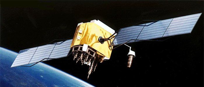
- The first Global Navigation Satellite System (hereafter "GNSS") was called the Global Positioning System ("GPS") network - which was first launched by the USA in the late 1970s.
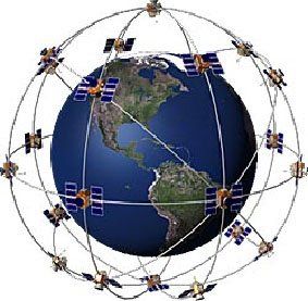
Figure 1: U.S. Global Positioning System (GPS)
(1)
- Since then modern civilisation has unquestionably developed an ever increasing dependence on global navigation systems.
- Along with GPS, there now exist other GNSS providers - including the (European based) Galileo network, the (Russian based) Glonass network and more recently the (Chinese based) BeiDou network.
- Common to all GNSS networks are:
- A network of satellites (orbiting approximately 20,000kms above earth) with extremely precise atomic clocks.
- Ground based GNSS receivers.
- Provided that a single GNSS receiver is able "see" 4 or more satellites, it can calculate its position on the planet.
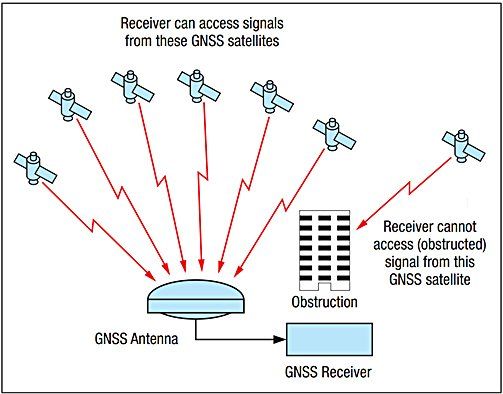
Figure 2: GNSS receiver with GNSS satellites transmitting their information needed for receiver to calculate its position.(2)
- However, accuracy (for a single GNSS receiver configuration) is typically only ±10 meters.
- Accuracy errors are due to: Satellite clock errors, Orbital errors, Atmospheric disturbance errors, GNSS receiver electrical noise, and multipath propagation.
- While an error of ±10 meters is perfectly acceptable in some situations (eg: To "Find My Friends"), it is totally inadequate for other applications (eg: Autonomous vehicles).
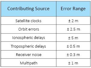
Figure 3: Contributing factors to GNSS positional error.(2)
- In the 1990s, a technology called Differential GNSS (DGNSS) was implemented to improve the accuracy of GPS to around 1-2 meters. More recent technology (such as RTK) improves the accuracy to 1-2 centimetres.
- DGNSS typically works by having a reference station in a known fixed location, and some form of radio link to a "rover". Since the reference station has a known location, any difference in the calculated position and its actual position can be considered as an error. This error or difference is then sent out to the rover via the radio link, allowing for the error to be subtracted at the rover.
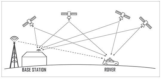
Figure 4: Diagram showing key features of DGNSS.
- Traditionally, the major downside of classic DGNSS is (high) setup cost and personal responsibility. That is, each operator wishing to implement a DGNSS solution has to pay thousands of dollars in setup costs, and is entirely responsible for the setup and maintenance of the network. This naturally inhibits many users from access to such technology.
So what is SBAS technology?
Much like DGNSS, the Satellite Based Augmented System (SBAS) also makes use of reference stations to provide correction data to the rover. However, rather than using a single reference station, SBAS makes use of several reference stations spread over the entire operational area. By using several reference stations, a map of the atmospheric effects is generated and this allows the system to cover large areas. Along with the atmospheric effects, the reference stations also allow for correction data of satellite orbital error and satellite clock errors to be accounted for. The correction information is then beamed to a geostationary satellite, which in turn broadcasts the correction data back to earth, allowing the rover to make a local correction. Since this correction data is sent over the existing GPS L1 channel, this can be received by existing GNSS receivers without the need for any additional antennas or hardware. This means that the existing single receiver GNSS devices could make use of this correction data with just a firmware update. Systems similar to SBAS have been available in the USA (Wide Area Augmentation System WAAS) and Europe for a number of years and allows for a positional accuracy of 1 - 2 m.
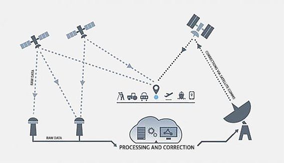
Figure 5: Diagram of SBAS core features.(3)
Why doesn't NZ and Australia have SBAS already?
Like all infrastructure, it takes plenty of time and money to roll out nationwide.
Time:
As this technology will ultimately be used for Saftey Critical applications (eg: Aviation), it is understandable that it needs to be thoroughly trailed and tested first.
In 2016 Land Information New Zealand (LINZ) announced that it was collaborating with Geoscience Australia (now called "Positioning Australia") in a two year trial of SBAS. As part of the SBAS test-bed trial, three technologies were assessed:
- Single frequency service SBAS - which is the equivalent of the current systems used in the US and Europe. Should enable accuracies of ±1m.
- Dual frequency/Multiple Constellation SBAS - known as "next generation SBAS" and will use the recent development of a civil frequency, known as L5 for GPS and E5a for Galileo. Should enable accuracies of sub ±1m.
- Precise Point Positioning (PPP) - which is a method that provides highly accurately position solutions with accuracy better than ±10cm. (Refer to our previous GNSS blog regarding the pros/cons of PPP).
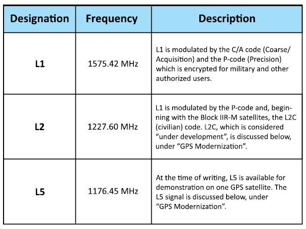
Figure 6 – Present GPS channels.(2)These trials (between January 2017 and January 2019) are thought to have been highly successful.
Read more at
Australian Flying.
Money:
Indeed, implementing this technology will not be a low cost exercise. Land Information New Zealand (LINZ) has set aside $NZ1.992 million in their 2019 Budget while Positioning Australia received $A160.9 million in their 2018-19 Federal Budget. Both will co-operate in delivering a regional satellite-based augmentation system for both countries. The funding will be used by LINZ and Positioning Australia to jointly develop specifications and to undertake initial procurement processes. Once a preferred provider for delivering SBAS has been identified, approval for further funding will be sought to implement a regional SBAS.
“GPS usually provides positioning information accurate to about 5-10 metres. This new system will improve the accuracy to less than a metre, and in some devices to 10 centimetres.”
“This data is fundamental to a range of applications and businesses worldwide. It increases our productivity, secures our safety and propels innovation.”
Matt Amos, LINZ National Geodesist.(4)
What are the benefits of SBAS?
In short, SBAS will make positioning data, like GPS, even more accurate than it is now.
Examples of SBAS applications include:
- Precision navigation for: manned and unmanned aircraft, driver-less cars and other autonomous vehicles.
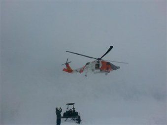
- Eg: SBAS could provide accurate vertical guidance for landing procedures for rescue helicopters, meaning they can reach patients in difficult terrain more quickly and in more challenging weather conditions such as low cloud.
- Virtual fencing where livestock in the future may wear GPS-enabled collars to stop them going where they are not supposed to – replacing some physical fences, keeping livestock out of waterways, and making grazing more efficient.
- Workplace health and safety, particularly in the forestry sector, where more accurate GPS can alert workers using equipment to other people in the area.

When will SBAS be available?
As mentioned above, it does take time to roll out such safety critical technology. Therefore New Zealanders (and Australians) will need to "hurry up and wait" before getting their hands on this new tech.
Investigations and procurement will be carried out this year and next. Tenders will apparently be out in 2021 and hence the technology is only slated to be operational in 2023. Read more here.
Conclusions:
At Beta Solutions we will continue to follow SBAS roll out closely as we are excited about the possibilities this new technology will unlock in the product design solutions we can offer our clients.
If you have a problem which could possibly be solved through the use of accurate Global Positioning, feel free to contact us to talk to someone in our knowledgeable team.
References:
- Figure 1. Retrieved from
https://www.google.com/search?q=precision+gps&hl=en&tbm=isch&source=lnt&tbs=sur:fmc&sa=X&ved=0ahUKEwjAr4uu1MzjAhUKfysKHdFrDzAQpwUIIw&biw=1731&bih=836&dpr=1.1#imgrc=mY4y84fY1W_4yM:
- Figure 2 and 3. Retrieved from
Jeffrey, C., (NovAtel, 2010). “An Introduction to GNSS.”
- Figure 5. Retrieved from CRCSI, (July, 2017).
“Technical Specifications Document for Satellite-Based Augmentation System (SBAS) Testbed.”
- Matt Amos, LINZ National Geodesist. Retrieved from
https://www.linz.govt.nz/data/geodetic-services/satellite-based-augmentation-system
- Images retrieved from:
Banner: https://www.nbcnews.com/technology/x-47b-navy-drone-take-first-stab-unmanned-carrier-landing-6C10591335
Rescue helicopter: https://coastguard.dodlive.mil/2014/02/from-air-station-to-ice-station/
Virtual fence: https://www.sott.net/article/134719-General-Law-for-Cows-Clever-collar-keeps-cows-in-a-virtual-paddock /
GSP Satellite: https://commons.wikimedia.org/wiki/File:GPS_Satellite_NASA_art-iif.jpg